California’s Central Valley Was Covered by an Unrelenting Tule Fog in Late 2025
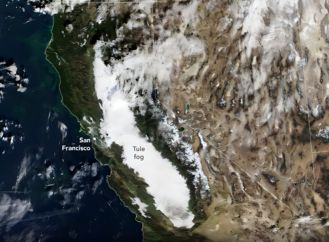
In late autumn 2025, a striking and persistent weather phenomenon took hold across California’s Central Valley, and it was impossible to miss—even from space. For more than two weeks, from late November into early December, a thick blanket of fog stretched across nearly 400 miles (about 640 kilometers) of the valley, running from Redding in the north to Bakersfield in the south. Satellite images captured this fog returning day after day, refusing to lift, earning it the description of an unrelenting tule fog.
This type of fog is not new to California, but the duration, scale, and consistency of the 2025 event made it especially noteworthy for scientists and weather observers.
What Exactly Is Tule Fog?
Tule fog is a form of radiation fog, a low-lying cloud that forms close to the ground. It is named after tule reeds, a sedge plant that historically grew in the marshes and wetlands of California’s Central Valley. Tule fog typically appears during the colder months, especially from late autumn through winter.
For tule fog to form, several conditions must come together:
- Moist soils, often following rain
- Clear nights that allow heat to escape from the ground
- Calm or very light winds
- Cooling air near the surface that becomes saturated with moisture
When these conditions align, water vapor condenses into tiny droplets, forming a dense fog layer that can linger for hours—or, in rare cases like 2025, for weeks.
A Fog Bank Seen From Space
During this event, the fog was so expansive that it was clearly visible in satellite imagery. Instruments such as MODIS (Moderate Resolution Imaging Spectroradiometer) on NASA’s Terra satellite and VIIRS (Visible Infrared Imaging Radiometer Suite) aboard the NOAA-20 and Suomi NPP satellites tracked the fog’s daily presence.
Between November 24 and December 9, 2025, images showed the Central Valley repeatedly filled with a bright white layer of fog. Most of the time, this fog remained trapped within the valley, bordered by the Coastal Range to the west and the Sierra Nevada to the east. On some days, however, the fog spilled westward through the Carquinez Strait, creeping toward the San Francisco Bay Area.
Why the Fog Lasted So Long
One of the key reasons this tule fog persisted was the exceptionally wet autumn that preceded it. Across central and southern California, rainfall totals from September through November 2025 ranked among the top 10 percent on record. This left valley soils saturated and primed to release moisture into the air.
At the same time, a stable high-pressure system settled over California in late November. High-pressure systems are known for acting like a lid, suppressing vertical air movement. In this case, it trapped moist air near the surface and prevented storms or winds from clearing out the fog.
With no significant weather systems moving through to disrupt the atmosphere, the fog layer remained remarkably stable. Day after day, it formed overnight and lingered well into daylight hours.
Temperature Patterns Under the Fog
Under the fog layer, temperatures in the Central Valley were noticeably cooler than in surrounding regions. Meanwhile, much of the rest of California experienced above-average temperatures during the same period.
Interestingly, despite the chilly conditions beneath the fog, the overall air mass over the state was still relatively warm. Scientists attributed this in part to warm ocean waters offshore and a low snowpack in the Sierra Nevada, which reduced the amount of cold air draining down into the valley.
These warmer background conditions may explain why some of the fog in 2025 behaved more like low stratus clouds, sitting slightly higher above the ground rather than forming the densest, ground-hugging fog seen in colder years.
How 2025 Compared to Past Fog Events
Historically, the Central Valley has experienced long stretches of tule fog. In 1985, for example, Fresno endured 16 consecutive days of dense fog, while Sacramento saw 17 straight days, according to historical weather reports.
However, research shows that tule fog has become less frequent in recent decades. Rising temperatures, changes in air quality, and shifts in regional climate patterns have all contributed to fewer foggy days overall. That makes the length and persistence of the 2025 event particularly striking.
Despite its duration, the fog in 2025 did not consistently reach the extreme density associated with some past events. In earlier decades, tule fog often caused near-zero visibility at ground level, leading to major traffic accidents and pileups. The slightly elevated fog layer in 2025 helped reduce some of those worst-case impacts.
Impacts on Daily Life and Transportation
Even when not at its densest, tule fog can still significantly affect daily life. Reduced visibility creates challenges for drivers, air travel, and outdoor activities. During the 2025 event, weather agencies issued repeated dense fog advisories, urging caution across large parts of the valley.
Roadways that cut through agricultural areas were especially affected, as fog tends to pool in low-lying terrain. While the 2025 fog did not result in the widespread major accidents seen in some historical events, it still posed ongoing safety concerns.
Why Farmers Care About Tule Fog
Tule fog is not just a weather curiosity—it plays an important role in Central Valley agriculture. Many fruit and nut trees, including almonds, pistachios, and stone fruits, require a period of winter dormancy to produce healthy crops.
Foggy, cool conditions help:
- Trigger plant dormancy
- Provide chill hours needed for proper flowering
- Shield buds from direct sunlight, which can cause premature warming
From this perspective, tule fog can be beneficial, even if it is inconvenient for commuters.
Tule Fog and a Changing Climate
Scientists continue to study how climate change may be altering fog patterns in California. Warmer nighttime temperatures make it harder for surface air to cool enough to form dense radiation fog. At the same time, changes in precipitation patterns influence soil moisture, another key ingredient.
The 2025 event highlights how short-term weather patterns, like a wet autumn and persistent high pressure, can still produce classic tule fog conditions—even as long-term trends point toward fewer foggy days overall.
A Rare but Revealing Event
The late 2025 tule fog episode was a reminder of how geography, weather, and climate interact in complex ways. The Central Valley’s shape, its surrounding mountain ranges, and seasonal moisture all worked together to create a fog event that was both visually dramatic and scientifically interesting.
Seen from satellites and felt on the ground, this fog was a powerful example of a familiar phenomenon behaving in an unusually persistent way—one that offered scientists valuable insight into both past patterns and future possibilities.
Research reference:
https://earthobservatory.nasa.gov/features/TuleFog
