Machine Learning Is Making Snowfall Forecasts Far More Accurate Across the Mountain West
Snowfall forecasting in the western United States has always been a difficult scientific challenge. Unlike flatter regions, the Mountain West is defined by complex terrain, sharp elevation changes, and highly localized weather patterns. A storm can drop heavy, wet snow in one canyon while delivering light, powdery snow just a few miles away. Because of this variability, snowfall forecasts in the region are often presented as broad ranges rather than precise numbers, limiting their usefulness for water managers, highway crews, ski resorts, and avalanche forecasters.
Now, a new study from researchers at the University of Utah shows that machine learning can significantly improve snowfall predictions by better estimating one critical factor: the snow-to-liquid ratio, or SLR.
Why Snowfall Forecasts in the West Are So Tricky
In simple terms, snowfall totals depend on more than just how much moisture falls from the sky. They also depend on snow density—how fluffy or compact the snow is when it reaches the ground. This is where SLR comes in.
SLR describes how many inches of snow are produced by one inch of liquid water. In the eastern United States, forecasters have long relied on a rough 10-to-1 rule, meaning ten inches of snow for every inch of water. While convenient, this rule does not hold up well in the West.
In mountainous regions, SLR can vary dramatically:
- Dense, slushy snow can have ratios as low as 2-to-1
- Exceptionally light powder can exceed 100-to-1
Using a single average value simply cannot capture that range. This is one of the main reasons snowfall forecasts in the West often lack precision.
The Central Role of Snow-Water Equivalent
The research team found that the single most important predictor of snow-to-liquid ratio is snow-water equivalent (SWE). SWE measures how much liquid water is contained within a layer of snow.
The relationship is straightforward: when storms produce higher SWE, the weight of the snow causes it to compact under its own mass, resulting in denser snow and lower SLR values. Lighter storms with lower SWE tend to produce fluffier snow with higher ratios.
Other factors also play meaningful roles, including:
- Elevation
- Air temperature
- Wind speed
- Atmospheric humidity
Together, these variables shape how snow forms, falls, and settles during each storm.
High-Quality Data Collected the Old-Fashioned Way
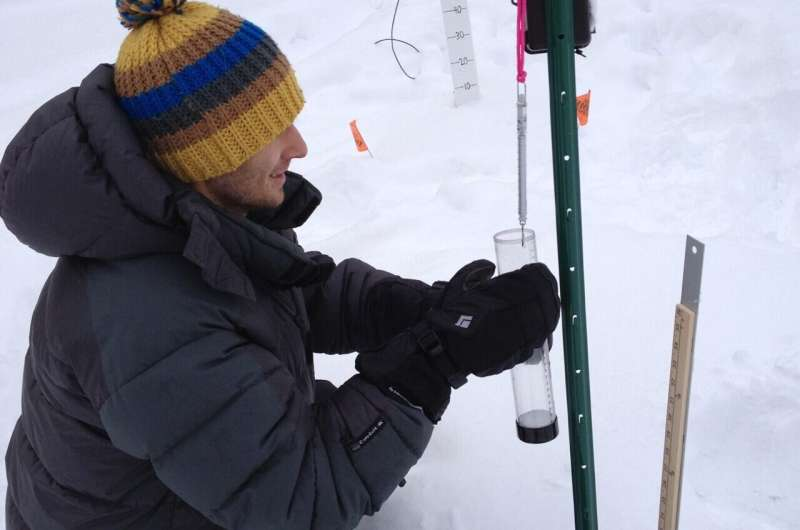
One of the most important aspects of this research is the quality of the data used to train the machine-learning models. Instead of relying primarily on automated weather stations, the researchers turned to manually collected snowfall measurements.
Over a six-year period, trained snow-safety professionals—many working for ski areas and transportation departments—collected daily or twice-daily measurements during storm cycles. These experts measured:
- Snow depth
- Snow-water equivalent
- Observation timing
Manual measurements are crucial in mountainous terrain because automated gauges often struggle in windy conditions, leading to underreported snowfall.
These data were gathered from 14 mountain sites across the western United States, including regions where avalanches pose serious risks and precise snow information is essential.
Where the Data Came From
The study included sites across several major mountain ranges:
- Utah: Alta in Little Cottonwood Canyon, Spruces Campground in Big Cottonwood Canyon, and Aspen Grove in Provo Canyon
- Cascade Range
- Sierra Nevada
- Locations in Colorado, Idaho, Wyoming, and Montana
These sites were chosen because they already maintained rigorous snowfall records for safety and operational purposes, making them ideal for scientific analysis.
How Machine Learning Improved Forecast Accuracy
Using this extensive dataset, the research team tested several machine-learning techniques to predict snow-to-liquid ratio based on atmospheric conditions. Among the models evaluated, a random forest algorithm emerged as the best balance between accuracy and computational efficiency.
While one more advanced algorithm showed slightly higher skill, it required ten times more processing power, making it impractical for real-time forecasting systems that must process huge datasets every six hours.
The random forest model delivered impressive gains:
- It explained nearly 50 percent of the variability in snow density
- Existing operational models typically explain less than 25 percent
This improvement represents a major step forward in translating atmospheric data into reliable snowfall totals.
Why This Matters in the Real World
More accurate snowfall forecasts have wide-ranging benefits across the West.
Water resource managers rely on snowpack data to estimate spring runoff and long-term water supply. Better SLR predictions mean more reliable projections of how much water is actually stored in the snow.
Highway and transportation agencies can make more informed decisions about road closures, plowing schedules, and safety warnings.
Avalanche professionals gain improved insight into snow density and loading, which are critical factors in avalanche formation.
Weather forecasters can provide clearer, more confident snowfall estimates to the public, especially during high-impact winter storms.
Moving Beyond the Outdated 10-to-1 Rule
One of the broader implications of this research is the need to move past overly simplistic forecasting assumptions. The 10-to-1 rule was developed decades ago for a very different climate and geography. Applying it universally, especially in the Mountain West, introduces avoidable errors.
Machine-learning approaches offer a way to adapt forecasts to local conditions, learning from real-world observations rather than relying on one-size-fits-all formulas.
Expanding the Research Nationwide
The University of Utah team is not stopping with the Mountain West. A follow-up study is already underway that applies the same methodology across the entire continental United States, using snowfall data from approximately 900 locations.
This expanded effort could help modernize snowfall forecasting nationwide, particularly as climate change continues to alter storm behavior, snow density, and precipitation patterns.
How Machine Learning Fits Into Modern Weather Forecasting
Machine learning is increasingly being used to complement traditional numerical weather prediction models. Instead of replacing physics-based simulations, these techniques enhance specific problem areas—like snow density—where traditional models struggle.
By learning directly from observations, machine-learning systems can capture subtle relationships that are difficult to represent mathematically, especially in environments as complex as mountainous terrain.
A Practical Step Forward for Winter Forecasting
This research shows that meaningful improvements in snowfall forecasting do not always require entirely new observing systems. Sometimes, the key lies in making better use of existing data, combined with modern analytical tools.
By pairing meticulous manual measurements with machine-learning algorithms that can handle complexity, scientists are closing long-standing gaps in winter weather prediction.
As these models are refined and expanded, people across snow-prone regions can expect forecasts that are not just more detailed, but also more dependable when they matter most.
Research paper:
https://doi.org/10.1175/WAF-D-24-0233.1
