Drones, AI, and Ducks: How Mizzou Engineers Are Shaping the Future of Wildlife Conservation

The University of Missouri (Mizzou) has taken wildlife conservation to new heights—literally. A team of researchers from Mizzou’s College of Engineering, led by Professor Yi Shang, has developed an innovative system that uses drones and artificial intelligence (AI) to monitor migratory waterfowl with remarkable accuracy. This approach promises to replace traditional aircraft-based surveys that are expensive, noisy, and sometimes dangerous.
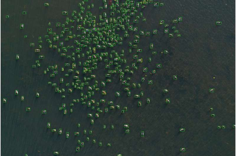
The project, published in the journal Drones (2025), is titled “New Methods for Waterfowl and Habitat Survey Using AI and Drone Imagery.” It introduces an end-to-end framework that can count birds, classify habitats, and even summarize findings automatically for wildlife agencies like the Missouri Department of Conservation (MDC).
Why Counting Ducks Matters
Monitoring waterfowl populations is essential for managing wetlands, planning conservation strategies, and regulating sustainable hunting. Traditional methods—such as ground surveys and manned aircraft counts—are costly, logistically demanding, and prone to human error. Observers can easily miss birds, double-count them, or be thrown off by camouflage and flock movements.
That’s where drones come in. They’re cheaper, safer, and can cover vast wetland areas quietly, without disturbing the animals. But capturing thousands of high-resolution images is just the start. The real challenge is analyzing them efficiently and accurately. That’s where AI steps in.
The Research Team’s New Approach
The Mizzou researchers combined drone imaging with a suite of AI tools to create a full data pipeline—from flight planning to species-level analysis. The system can identify birds, classify their surroundings, and avoid double-counting.
Here’s how it works:
1. Smart Flight Planning
Using specialized flight-planning software, the team configures the drone’s altitude, speed, and image overlap to ensure the images are both clear and comprehensive. This minimizes gaps and helps the AI correctly recognize the same bird from multiple angles.
2. AI-Powered Detection
Once the drone collects the images, an advanced deep-learning model—specifically Faster R-CNN—scans each photo to detect birds. On the test dataset, this model achieved around 86.6% mean average precision (mAP), which is impressive considering the visual complexity of wetland environments.
3. Habitat Segmentation
The researchers didn’t stop at identifying birds. They wanted to understand where the birds were—on open water, in vegetation, or resting on dry fields. To do this, they used Meta’s Segment Anything Model (SAM) combined with a ResNet50 classifier, achieving about 85.1% accuracy with an F1 score of 81.8%. This step allows conservationists to understand habitat preferences and conditions.
4. Overlap and Duplication Detection
Because drone photos often overlap, the system includes an algorithm that identifies duplicate bird sightings across consecutive images. This reduces double-counting errors to less than 5%, ensuring the final bird counts are reliable.
5. Automated Reporting with Language Models
Finally, the data pipeline integrates large language models (LLMs) to generate plain-language summaries of the results. These reports help wildlife managers interpret the findings quickly, without needing technical expertise in AI or image processing.
How Accurate Is It?
Accuracy depends on the environment. When counting birds on open water, the system performs with more than 95% accuracy. Even in difficult conditions—where birds overlap or hide under vegetation—it maintains a strong 80–85% accuracy rate. That level of precision, combined with automation, marks a huge improvement over traditional human-led aerial surveys.
Real-World Impact
This new approach is already being applied to track mallards and northern pintails, two common duck species in Missouri. The Missouri Department of Conservation is testing how this method could replace or supplement conventional surveys. The system not only counts ducks but also analyzes habitat conditions, helping agencies better manage wetlands and migration corridors.
In the long run, this combination of AI and unmanned aerial vehicles (UAVs) could extend far beyond Missouri’s wetlands. It could be used to monitor deer, shorebirds, and other wildlife species across different ecosystems. The modular design means it can adapt easily to new habitats, species, and conservation goals.
Why This Technology Matters
Wildlife monitoring has always been a balancing act between accuracy, cost, and impact on animals. Traditional methods like manned flights can stress wildlife and rely heavily on human interpretation. With drones and AI, researchers gain precise, repeatable data without disturbance.
Moreover, the integration of machine learning and computer vision eliminates bias and fatigue that can affect human observers. It also allows for large-scale monitoring across seasons—something nearly impossible through manual observation.
As drone technology continues to advance—bringing higher-resolution cameras, longer flight times, and lower costs—its applications in ecology and conservation will only grow. Combining drones with AI will make it easier to monitor endangered species, track environmental changes, and assess restoration projects.
A Broader Look: Drones in Modern Conservation
The Mizzou study is part of a global trend where technology meets ecology. Across the world, drones are now used to:
- Map coral reefs and monitor bleaching.
- Count penguins in Antarctica.
- Track elephant herds in Africa to prevent poaching.
- Survey deforestation and illegal logging.
- Measure glacier retreat and coastal erosion.
These drones act as the eyes of scientists in places that are remote or dangerous. Their ability to collect data quickly and safely has revolutionized field research.
Meanwhile, AI has become a silent partner in this revolution. Machine learning models can now detect animal species, recognize individual whales by their tails, and even predict where endangered animals might appear next based on movement patterns and weather data.
Challenges and Limitations
While the technology is promising, it’s not without challenges.
- Complex environments: Densely vegetated wetlands and overlapping flocks make detection more difficult.
- Weather dependency: Drones struggle in rain, fog, or strong winds.
- Data processing: High-resolution imagery demands powerful computers and long processing times.
- Regulations: Flight permissions and wildlife disturbance rules vary by region.
- Ethics and privacy: Even in nature, drone use must balance data collection with minimal disruption to animals.
However, as AI models improve and hardware becomes cheaper, these limitations are expected to shrink. The Mizzou team’s work is a clear step in that direction.
The Bigger Picture
This research is not just about counting ducks—it’s about reimagining how humans interact with nature through technology. The combination of engineering precision, biological understanding, and data science has opened up new possibilities for protecting biodiversity.
The system’s integration with large language models is particularly forward-thinking. It bridges the gap between data and decision-making, allowing agencies and policymakers to receive clear, readable summaries instead of raw technical outputs.
As conservation becomes increasingly data-driven, such tools will be essential. They don’t replace field biologists but empower them with better insights and faster analysis.
Final Thoughts
The University of Missouri’s breakthrough shows that the future of conservation doesn’t just lie in remote rainforests or Arctic ice—it’s also being built in engineering labs. With over 95% accuracy in ideal conditions and sophisticated AI-driven analytics, this system demonstrates how drones and artificial intelligence can transform the way we understand and protect wildlife.
By embracing technology, conservationists are gaining a powerful ally in the fight to preserve natural ecosystems—one quiet drone flight at a time.
Research Reference:
Zhenduo Zhai et al., “New Methods for Waterfowl and Habitat Survey Using AI and Drone Imagery,” Drones (2025)


