A Subtle Return of La Niña Is Cooling the Pacific and Raising New Questions About Global Weather
A weak La Niña has quietly returned to the equatorial Pacific Ocean, and scientists are paying close attention to what this subtle shift could mean for weather and climate patterns in the coming months. While La Niña is a familiar part of Earth’s natural climate rhythm, this latest appearance stands out for its mild strength, making its potential impacts harder to pin down than usual.
After several months of relatively neutral conditions, La Niña began to re-emerge in September 2025 and continued through December 2025. This return marks the cooler phase of the El Niño–Southern Oscillation (ENSO) cycle, a powerful ocean–atmosphere system that plays a major role in shaping climate patterns around the world. However, unlike stronger La Niña events of the past, this one is comparatively weak, leaving scientists cautious about predicting exactly how it will influence upcoming seasons.
At its core, La Niña develops when easterly trade winds across the tropical Pacific strengthen. These winds push warm surface waters westward toward Asia and Australia, allowing colder, deeper water to rise to the surface in the eastern tropical Pacific. This process, known as upwelling, cools large areas of the central and eastern equatorial Pacific Ocean. In late 2025, this cooling became noticeable enough for scientists to confirm that La Niña conditions had returned.
According to the NOAA Climate Prediction Center, below-average sea surface temperatures associated with La Niña were firmly in place by early December 2025. NOAA scientists expect these conditions to persist for another month or two, although their long-term influence remains uncertain due to the event’s limited intensity.
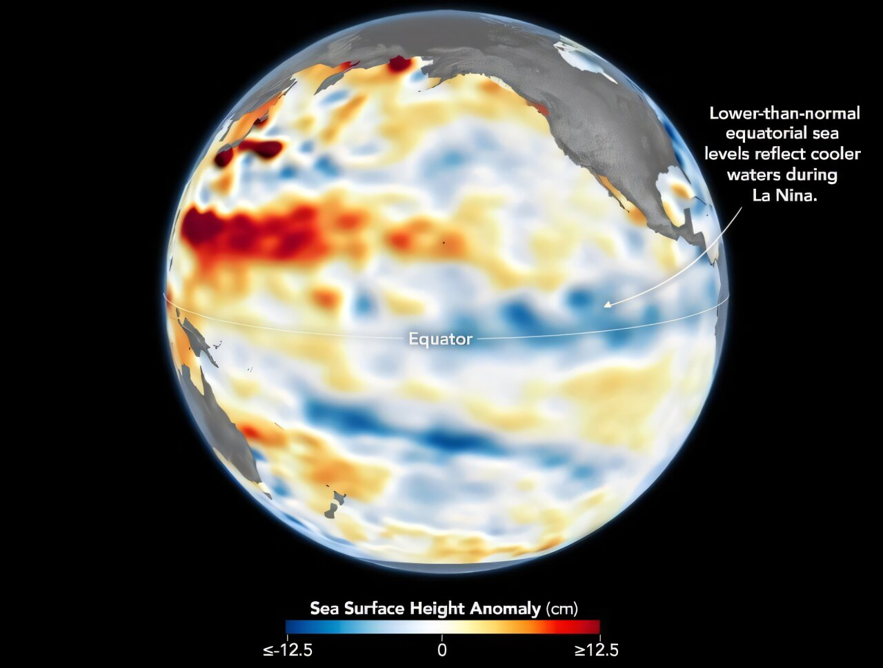
One of the lesser-known but important consequences of La Niña involves sea level changes. Cooler water is denser than warm water and takes up less space, which causes sea levels in the central and eastern Pacific to drop during La Niña episodes. Satellite observations from December 1, 2025, clearly show this pattern. Areas with lower-than-normal sea levels appear in shades of blue, while regions with higher-than-normal levels show up in red, and near-normal conditions appear white.
These detailed measurements come from the Sentinel-6 Michael Freilich satellite, a joint mission designed to track sea surface height with remarkable precision. Scientists at NASA’s Jet Propulsion Laboratory (JPL) processed the data, carefully removing seasonal cycles and long-term sea level rise trends to highlight short-term changes linked to ENSO and other natural variations. This makes it easier to see La Niña’s fingerprint on the ocean.
Adding to the scientific toolkit, Sentinel-6 Michael Freilich now has a twin. Sentinel-6B, launched in November 2025, is expected to begin contributing data to ENSO research and forecasting sometime in 2026, further improving scientists’ ability to monitor subtle ocean changes.
Beyond the ocean itself, La Niña’s influence extends into the atmosphere, where it alters the exchange of heat and moisture between sea and sky. This ocean–atmosphere coupling can reshape global circulation patterns, including the position and strength of jet streams. These shifts are why La Niña is often linked to wetter conditions in some regions and drought in others.
In a typical La Niña year, the American Southwest tends to experience below-average rainfall, while the Pacific Northwest often sees above-average precipitation. However, when La Niña is weak—like this current event—those patterns are far from guaranteed. Climate scientists emphasize that mild ENSO events are notoriously difficult to predict, as their atmospheric signals may not be strong enough to dominate other climate influences.
Even so, there is still a possibility that this weak La Niña could nudge winter conditions toward the drier side in parts of the southwestern United States. The key word here is potential. With a mild event, La Niña acts more like a gentle push than a firm steering wheel, and other factors can easily override its effects.
Why Weak La Niña Events Are Tricky to Forecast
Strong El Niño or La Niña events tend to produce clearer, more consistent global patterns. Weak events, on the other hand, often result in mixed or uneven impacts. Small variations in wind strength, ocean temperature, or atmospheric pressure can make a big difference in how weather unfolds. This is why forecasters remain cautious and emphasize probabilities rather than certainties.
A Quick Refresher on ENSO
The El Niño–Southern Oscillation is a naturally occurring cycle involving changes in ocean temperatures and atmospheric circulation across the tropical Pacific.
- El Niño features warmer-than-average sea surface temperatures and often brings increased rainfall to some regions while drying others.
- La Niña, its cooler counterpart, generally produces the opposite pattern.
- ENSO-neutral conditions occur when neither phase dominates.
ENSO events typically develop every two to seven years, and their impacts can ripple across continents, influencing monsoons, hurricanes, droughts, and even wildfire risk.
La Niña in a Warming World
It’s also important to view this La Niña within the context of long-term climate change. While global warming does not stop ENSO cycles from occurring, it can influence their background conditions. Warmer oceans overall mean that even “cooler-than-average” La Niña waters today may still be warmer than similar events decades ago. Scientists continue to study how climate change may affect the frequency, intensity, and impacts of future ENSO events.
What Happens Next
For now, scientists will keep monitoring sea surface temperatures, trade winds, and atmospheric patterns as this weak La Niña continues to unfold. With the help of advanced satellites like Sentinel-6 and ongoing NOAA analyses, researchers are gathering valuable data that will improve forecasts—not just for this event, but for ENSO cycles in the years to come.
Whether this subtle La Niña fades quietly or manages to leave a noticeable mark on global weather, it serves as a reminder that even small shifts in the Pacific Ocean can have far-reaching consequences for the planet.
Research Reference:
https://www.cpc.ncep.noaa.gov/products/analysis_monitoring/enso_advisory/ensodisc.html
