Sentinel-4 Sends Back Its First Look at Earth’s Air Pollution — A New Era in Hourly Atmospheric Monitoring
Europe’s brand-new Copernicus Sentinel-4 satellite has just delivered its first images of air pollutants hanging over the continent — and the results are stunning. From a perch 36,000 kilometers above Earth, this instrument is giving scientists their clearest view yet of nitrogen dioxide, sulfur dioxide, and ozone across Europe and North Africa. While these first snapshots are still part of the satellite’s commissioning phase, they mark a major step forward in how we track the air we breathe.
What Is Sentinel-4 and Why It’s Special
Sentinel-4 is part of the Copernicus Programme, Europe’s flagship Earth-observation initiative. What makes it stand out is its orbit. Instead of circling Earth like most satellites, Sentinel-4 rides aboard the Meteosat Third Generation Sounder (MTG-S1) satellite in geostationary orbit. That means it stays locked over the same area — Europe and northern Africa — all day, every day.
Because of this fixed position, Sentinel-4 can provide hourly updates on air quality. Compare that to satellites in lower orbits, which might only scan a region once a day. This constant monitoring capability is a game-changer for pollution tracking and forecasting.
The mission launched on July 1, 2025, aboard a SpaceX Falcon 9 rocket from Florida. It’s equipped with an ultraviolet, visible, and near-infrared (UVN) spectrometer, capable of detecting subtle spectral “fingerprints” left by gases and aerosols in sunlight reflected from Earth’s surface and atmosphere.
The First Images — A Clearer Picture of What’s in the Air
On October 8, 2025, Sentinel-4 collected its first atmospheric measurements. Just a few days later, the European Space Agency (ESA) released several striking images that reveal how this new tool sees our atmosphere.
1. Nitrogen Dioxide (NO₂)
The first image highlights tropospheric nitrogen dioxide — one of the most harmful air pollutants produced mainly by cars, power plants, and industrial combustion. The map shows pollution hotspots along the Mediterranean coast and across Italy’s Po Valley, a region long known for poor air quality.
Some areas appear blank because clouds block Sentinel-4’s view; the satellite can’t measure gases through thick cloud cover. Still, this early image confirms that the system is working perfectly, capturing the daily rhythm of emissions from human activity.
2. Sulfur Dioxide (SO₂)
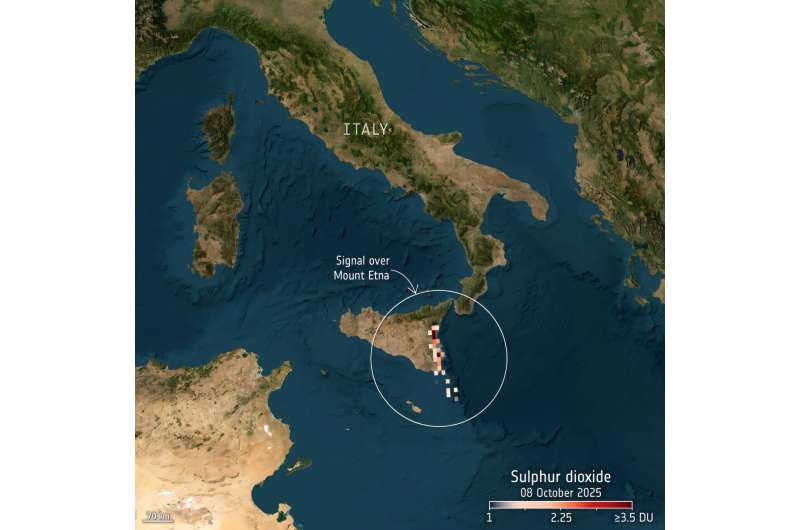
Another image focuses on sulfur dioxide, revealing a plume drifting southeast from Mount Etna in Sicily. This volcanic gas is also emitted by ships and coal-fired power stations. Even though Etna was relatively calm at the time, Sentinel-4 clearly detected the smaller release — proof of the sensor’s sensitivity.
Sulfur dioxide not only irritates lungs but also forms fine particulate matter (PM2.5) when it reacts in the atmosphere, worsening health risks and reducing visibility.
3. Ozone (O₃)
The third image maps ozone concentrations in the lower atmosphere. Ozone plays a double role: it’s vital high in the stratosphere where it shields life from ultraviolet rays, but down near the surface, it becomes a harmful pollutant.
The data show higher ozone levels over the Balkans and Greece, and lower levels over the Baltic region, consistent with readings from other European satellites like GOME-2 (MetOp) and TROPOMI (Sentinel-5P).
4. Earth Radiance Map
A fourth image shows Europe and North Africa in false color, based on Sentinel-4’s first light measurements. This confirms that the satellite’s optical and calibration systems are operating as designed.
The Team and the Technology Behind It
These first results are the combined effort of the European Space Agency (ESA), EUMETSAT, the European Commission, and several national institutes — including the University of Bremen’s Institute of Environmental Physics, the German Aerospace Center (DLR), and the Royal Belgian Institute for Space Aeronomy.
The partners report that the satellite is healthy, its calibration systems are on track, and its data pipelines are performing well. Once fully operational, Sentinel-4 will routinely monitor nitrogen dioxide, sulfur dioxide, ozone, formaldehyde, glyoxal, and aerosols, providing vital input to the Copernicus Atmosphere Monitoring Service (CAMS).
This service integrates space-based data into European air-quality models, helping policymakers, scientists, and the public understand pollution dynamics in real time.
Why Sentinel-4 Matters
Air pollution is one of the largest environmental threats to human health, causing millions of premature deaths annually. Nitrogen dioxide and sulfur dioxide contribute to smog, acid rain, and respiratory illness, while ground-level ozone worsens asthma and other lung conditions.
With hourly observations, Sentinel-4 will allow scientists to track short-term pollution spikes — like morning rush-hour emissions or industrial bursts — that daily measurements often miss. These rapid updates can improve air-quality forecasts, early-warning systems, and environmental policies.
The satellite’s geostationary vantage point also allows Europe to observe weather–pollution interactions, such as how temperature inversions or wind patterns trap and spread pollutants.
Connecting Europe to Global Air Monitoring
Sentinel-4 is part of a growing global constellation of geostationary air-monitoring missions. Together with NASA’s TEMPO satellite over North America and GEMS over Asia, the system is building a nearly continuous global view of air quality.
This means scientists will soon be able to follow how pollutants move from continent to continent, tracking transboundary air pollution in near real time. For example, they’ll be able to observe how Saharan dust or industrial emissions from one region affect air quality thousands of kilometers away.
A New Benchmark for Data Quality
Sentinel-4’s spectral resolution of about 8 km allows for detailed regional mapping. While that’s not as fine as ground sensors, the trade-off is worth it — because the satellite can watch the same area every hour, revealing daily cycles of pollution that stationary stations can’t capture.
The satellite’s lifetime is expected to be around 8.5 years, ensuring a long-term data record for tracking air-quality trends. Its data will be open and freely available, supporting everything from academic research to citizen-science projects and environmental journalism.
What Comes Next
The mission is still in its commissioning phase, meaning engineers are fine-tuning its instruments and data-processing systems. Full operations are expected to begin within a few months.
Once active, Sentinel-4’s data will feed into the European air-quality monitoring infrastructure, providing hourly updates that cities and national agencies can use to forecast pollution, evaluate emission regulations, and respond to environmental emergencies.
This is more than just a technical milestone — it’s a major step toward cleaner air and better environmental awareness. Europe now joins the ranks of regions capable of continuous atmospheric surveillance, a tool that can directly support climate policy and public health.
Understanding the Pollutants Sentinel-4 Tracks
To appreciate Sentinel-4’s impact, it helps to understand what it’s measuring:
- Nitrogen Dioxide (NO₂): Produced mainly by combustion engines and power plants, NO₂ is toxic at high concentrations and contributes to ozone and particulate formation.
- Sulfur Dioxide (SO₂): A gas linked to fossil-fuel combustion and volcanic activity. It irritates lungs and forms secondary pollutants like sulfates.
- Ozone (O₃): Beneficial in the upper atmosphere but harmful near the surface, where it results from sunlight-driven reactions between NO₂ and volatile organic compounds.
- Formaldehyde and Glyoxal: Indicators of volatile organic compounds and biomass burning, important for understanding secondary pollutant chemistry.
- Aerosols: Fine particles that influence both climate and health, affecting cloud formation and radiation balance.
By monitoring all of these together, Sentinel-4 can show how different pollutants interact — something crucial for both climate modeling and public health research.
Looking Ahead
Sentinel-4’s early success underlines the strength of European collaboration in space science. The mission combines innovation, engineering precision, and environmental urgency into a single platform. As it transitions from testing to routine operation, the data it provides will help scientists unravel the complex chemistry of the atmosphere and policymakers craft more informed decisions.
For the everyday citizen, the biggest benefit will come through better air-quality forecasts — knowing when pollution levels rise, how long they might last, and what actions can mitigate exposure.
It’s not an exaggeration to say Sentinel-4 is ushering in a new era of air-pollution monitoring — one that watches Europe’s skies every hour, every day, from space.
Research Reference: ESA – Sentinel-4 offers first glimpses of air pollutants (2025)

